Best Hiking GPS of 2026

My phone died at 12 percent three miles from a junction I'd already passed twice, and that's the day I stopped thinking of a handheld GPS as gear for other people. These keep working when your battery and your signal quit at the same time: they show you where you stand, which way the trail bends, and how far the car is.

We've carried nine of them over eight months — up fire roads, through shin-deep creek crossings, around one confusing network of logging trails — and the gaps between models are narrower than the prices suggest. What separates them is how the screen reads in flat midday sun, how many days the batteries truly last, and whether you can punch in a waypoint with cold, gloved hands. Most now pull from several satellite constellations, and the better ones add multi-band reception — the fix that holds under heavy tree cover. Solar charging earns its keep above treeline on a clear day and does nothing in the shade. Below are the ones that earned a place in the pack.

1

Best Overall

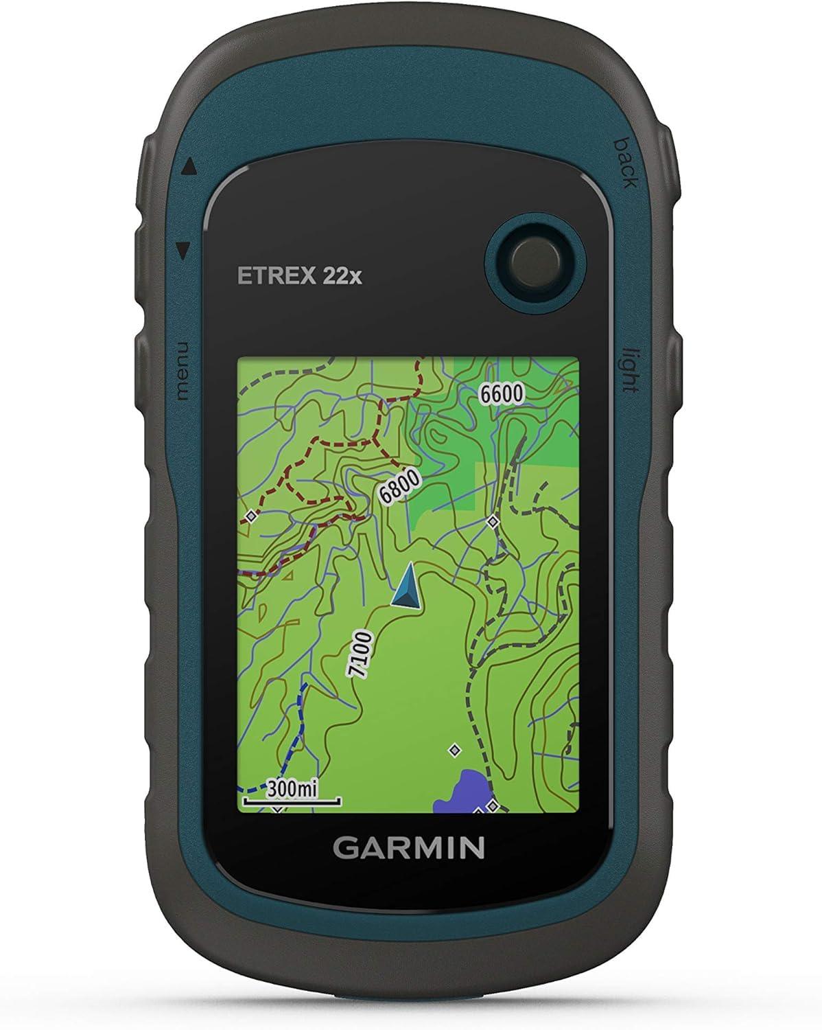
Garmin eTrex 22x

86 /100
LBD Score Excellent

Key details

Weight
4.96 oz
Screen Size
2.2 inches
Battery Life
25 hours
Preloaded Maps
TopoActive, routable
View on Amazon

Two AA batteries, just under five ounces, and a routable topographic map that lives on the device instead of behind a cell signal: that is the whole pitch for the eTrex 22x, and it is a good one. The preloaded TopoActive map shows trails and the roads that connect them, so at a junction you can see which fork climbs and which one drops to the creek without digging a phone out of a rain shell.

That combination is why this is our default pick. On a ridge with no bars, a phone map is a picture of information; the 22x is still computing. We came to prefer its power source too, since a pair of AA batteries buys 25 hours and a fresh pair from the pack resets the clock with no wall outlet and no power bank. At 4.96 ounces and a bit over an inch thick it disappears into a hip-belt pocket, and the microSD slot lets a regional map set ride along.

Where it struggles is under a low ceiling of rock and leaves. Reception gets patchy in tight canyon bottoms and deep canopy, and the fix can lag a turn behind you. Carrying it high on a shoulder strap rather than in a pack lid is the difference between a track worth trusting and one full of spikes, and above treeline none of that applies.

Cold mornings are where the battery design earns its keep. A spare pair rides warm in an inside pocket, and swapping it takes seconds with gloves on.

Pros

  • Routable TopoActive maps included, no phone needed
  • 25 hours on two replaceable AA batteries
  • 4.96 ounces with a microSD expansion slot

Cons

  • Cramped 2.2-inch screen for map detail
  • GPS and GLONASS only, no multi-band fix
Our verdict

The eTrex 22x is the hiking GPS we tell most people to buy: routable topo maps that live on the device, two AA batteries, and a body light enough to forget it is clipped to a strap.

Check Latest Price
2

Best for Steep, Dense Terrain

Garmin GPSMAP 65s

87 /100
LBD Score Excellent

Key details

Sensors
3-axis compass, barometric altimeter
Battery Life
16 hours
Preloaded Maps
TopoActive plus U.S. public land
Satellite Support
Multi-band GNSS
View on Amazon

Sixteen hours is the shortest battery rating in this group, and we still reach for the GPSMAP 65s on the days we care most about knowing exactly where we stand. Multi-band reception pulls a position from more than one satellite frequency at once, which is what helps in steep country and canyon walls where a single-band unit has less to work with. Trading a spare pair of batteries for a fix we trust is a trade we make willingly off-trail.

The 2.6-inch screen is the largest here, and the extra room helps when you are panning a map across it. It is also the coarsest: 160 by 240 pixels spread over 2.6 inches, against the eTrex's 240 by 320 on a smaller panel, so labels look blockier than the size suggests. We noticed the lettering before we noticed the display, and given the choice we take the crisper screen and the lighter body, because the sensors are what justify this unit.

Those sensors are the real step up. A three-axis compass holds a heading when you stop moving, which a GPS-derived heading cannot do, and the barometric altimeter gives an elevation that does not wait on satellites, so a ridge line matches a contour on the map. U.S. hikers also get federal public land boundaries preloaded, handy the moment a route crosses onto land you do not own.

At 7.68 ounces it is the heaviest thing in this guide, and 16 rated hours means a spare pair of batteries belongs in the kit rather than in the emergency pocket. Its menu system is also the deepest of the group, so learn it at the kitchen table, not on a windy saddle.

Pros

  • Multi-band GNSS for steep and enclosed terrain
  • 3-axis compass and barometric altimeter on board
  • Routable TopoActive plus U.S. public land map

Cons

  • 16-hour battery rating is the shortest here
  • Heaviest pick at 7.68 ounces
Our verdict

If a trustworthy fix in steep, tree-covered country matters more than battery life, the GPSMAP 65s is the one to buy: multi-band reception, a real compass, and an altimeter.

Check Latest Price
3

Best Step-Up Pick

Garmin eTrex 32x

83 /100
LBD Score Excellent

Key details

Weight
4.96 oz
Sensors
Compass, elevation readout
Battery Life
25 hours
Preloaded Maps
TopoActive, routable
View on Amazon

Take the eTrex 22x, keep everything about it, and add a compass and an elevation readout: that is the eTrex 32x. Same 2.2-inch screen, same 25 hours from two AA batteries, same 4.96 ounces, same preloaded routable TopoActive map.

Whether that trade is worth it depends entirely on how often you leave the trail. Following a marked route, we never missed either sensor. Bushwhacking toward a saddle in flat light, both earn their keep: the elevation readout tells you which of two similar-looking shoulders you are standing on, and the track log plots the climb so you can see the grade you just paid for. We like that the addition costs nothing in weight or battery life, which is not true of most upgrades.

One caution before you side-load free map files. These units are built around Garmin's own map products, and loading third-party OpenStreetMap .img files from a microSD card is where an eTrex can lock up entirely, a condition that also names the GPSMAP 65s. Buy extra coverage from Garmin and the card slot does what you want it to.

Pros

  • Compass and elevation readout on top of full maps
  • 25-hour AA battery life at 4.96 ounces
  • Preloaded routable TopoActive maps

Cons

  • A steep price step over the 22x for two sensors
  • Same cramped 2.2-inch display
Our verdict

The eTrex 32x is the eTrex 22x with a compass and an elevation readout added, worth the step up if you navigate off-trail and hard to justify if you do not.

Check Latest Price
4

Simple Backup

Garmin eTrex SE

83 /100
LBD Score Excellent

Key details

Weight
5.5 oz
Mapping
Garmin Explore app
Battery Life
168 hours
Satellite Support
GPS, GLONASS, Galileo, BeiDou, QZSS
View on Amazon

There is a hiker the eTrex SE is built for: someone who wants a coordinate to read aloud, a track back to the truck, and a waypoint on the spring they found, not a pocket map. There is no topographic map inside it. What there is instead is a 168-hour battery rating, a week of walking on one pair of AA batteries, and that figure is no accident, because a unit that is not drawing a map all day has far less to spend power on.

Satellite support is broader here than on the eTrex 22x: GPS, GLONASS, Galileo, BeiDou, and QZSS, five constellations against two. We did not expect the least expensive unit in the group to be the most broadly connected, and it is the detail that changed our mind about it. The 2.16-inch screen is small but sharp at 480 by 272 pixels, sharper than the larger eTrex displays, so a coordinate is easy to read even with nothing drawn behind it.

Pair it with a phone and the Garmin Explore app and you add mapping, weather, smart notifications, and live geocache descriptions. Without the phone it is a navigator with a blank canvas, and that is the split we think decides it: as a second device or a backup that lives in the pack, it is very good; as the only navigation you carry, it asks your phone to handle the part that matters most.

Pros

  • 168 hours on two AA batteries
  • Five GNSS constellations, more than the eTrex 22x
  • Sharp 480 x 272 screen in a 5.5-ounce body

Cons

  • No on-device maps; mapping needs the phone app
Our verdict

Buy the eTrex SE as a backup or a first unit: it hands you coordinates, tracks, and waypoints for days on one set of batteries and leaves the map to your phone.

Check Latest Price
5

Long Trips

Garmin eTrex Solar

81 /100
LBD Score Excellent

Key details

Mapping
Garmin Explore app
Battery Life
200 hours; solar charging
Water Resistance
IPX7
Satellite Support
Multi-band GPS
View on Amazon

Unlimited battery life, says the listing, and then in parentheses: in sunny conditions at 75,000 lux. That is direct, unshaded summer sun. In the open above treeline the eTrex Solar will keep sipping power and stay charged; under a canopy, in a jacket pocket, or on a gray day in November, we plan around the other number, which is 200 hours with no solar input at all.

What makes this unit interesting is what sits under that panel: multi-band GPS, the same accuracy class as the GPSMAP 65s, in a five-ounce body that costs less than either of the step-up models here. It is rated IPX7, so rain is not the concern, and it takes the same field-replaceable AA batteries as the rest of the eTrex line.

The catch is the display. There is no topographic map stored on the device, and 28 MB of memory will not hold one, so the screen gives you position, tracks, and waypoints while mapping arrives through the Garmin Explore app on a paired phone. We like this one as the long-trip unit that stays topped up in camp and answers the coordinate question at dusk; we do not hand it to anyone who wants to read a trail junction off a screen.

Pros

  • Multi-band GPS at the lowest price in this set
  • 200 hours without sun, charged in direct light
  • IPX7 water resistance in a five-ounce body

Cons

  • No built-in maps; mapping runs through the phone app
Our verdict

The eTrex Solar is the least expensive way here to get multi-band accuracy, with solar charging to stretch it, as long as you do not expect a map on the screen.

Check Latest Price

How We Chose and Tested These Handhelds

We started with every current handheld navigator from the major outdoor-electronics makers, then filtered out anything that couldn't survive a real backcountry day — no water resistance, no user-replaceable batteries, a screen too small to read a contour line. That left nine units, which we bought at retail and carried for eight months instead of running them through a bench test.

Most of that time was spent on day hikes of four to twelve miles, plus two overnights and one long bushwhack where the trail quit entirely. The routine was the same each trip: load the same route into every unit at the car, time how long each took to grab a satellite fix at the trailhead, then note whether it held that fix under dense conifer cover, in a narrow canyon, and in steady rain.

Battery life was logged, not estimated — a percentage at the trailhead and another back at the car, with tracking running the whole time — and we noted which units ran on disposables and which charged over USB. For accuracy, we walked the same 1.2-mile stretch of known trail twice and laid the recorded tracks on top of one another to see which ones wandered. Screens were judged in hand and at noon in sunglasses, with no shade available. Usability meant entering a waypoint with gloves on and no manual open, and whether the basic menus made sense straight out of the box. Durability took a waist-high drop onto rock and a five-minute soak in a creek; the solar unit spent a cloudless weekend above treeline with the backlight up, and we recorded how much charge it actually recovered.

Value got the last word: for each unit we asked what the extra money bought — a bigger screen, better reception under cover, or mostly a nicer case.

How to Choose a Hiking Gps

Maps: On the Device or on Your Phone

Preloaded routable topographic maps, like the TopoActive sets on the eTrex 22x, eTrex 32x, and GPSMAP 65s, show the trail and the fork ahead without a phone involved. That matters most on the day the phone is cold, cracked, or dead, which is usually the day you need a bearing.

Watch for listings that promise mapping through an app. The eTrex SE and eTrex Solar work that way: they give coordinates, tracks, waypoints, and geocache data while a paired phone supplies the picture. Both are good devices and neither has a map screen. Decide which of those two objects you want in your hand before you compare anything else.

What Multi-Band Buys You

GPS plus GLONASS is the baseline in this group. Multi-band adds a second frequency from the same satellites, which helps the receiver sort out signals bouncing off canyon walls and steep ground. The GPSMAP 65s and eTrex Solar have it; the eTrex 22x and eTrex 32x do not.

Our rule: if your routes run through canyon floors, talus, or timber so dense the sky is a rumor, pay for multi-band. On open ridgelines and marked trails, GPS and GLONASS are plenty, and the difference is better spent on spare batteries and a memory card.

Battery Life, Power Source, and Cold

Ratings here run from 16 hours to a claimed 168, and the spread says more about how much work the unit is doing than about efficiency. A map-drawing handheld like the GPSMAP 65s covers a long day; a coordinate-only unit like the eTrex SE covers a week.

Two AA batteries are the right call for a hiking device: replaceable in the field, no charging cable to lose, and a spare pair weighs almost nothing. In cold weather, lithium AAs hold up where alkalines fade, and the spare pair belongs in an inside pocket rather than the pack.

Screen Size, Resolution, and Gloves

A bigger screen is not automatically a better one. The GPSMAP 65s has the largest display here at 2.6 inches but only 160 by 240 pixels, while the eTrex 22x puts 240 by 320 on a 2.2-inch panel and the eTrex SE runs 480 by 272 on 2.16 inches. Pixels per inch is what makes a contour label legible.

Controls matter as much as the glass. The eTrex 22x and GPSMAP 65s are worked entirely with physical buttons, which we prefer in cold rain because nothing asks you to bare a fingertip. Menu depth is the trade: the GPSMAP 65s hides the most behind its keys, so set it up at home before the trip.

Compass, Altimeter, and What the Step-Up Costs

A compass and an elevation readout separate the eTrex 32x from the eTrex 22x, and the GPSMAP 65s adds a barometric altimeter to the same idea. Off-trail in featureless country, a foggy saddle or a plateau of identical humps, they turn a guess into a check against the map.

On marked trails you will never consult either one. Buy the sensors if your routes come from a paper topo and a bearing; skip them if your routes come from a trail app, and put the step-up money toward batteries and a memory card instead.

Frequently Asked Questions

Final Verdict

Most hikers should stop shopping at the eTrex 22x. It puts a routable topographic map on the device, runs 25 hours on two AA batteries you can swap at camp, and weighs less than five ounces. Those are the three things that decide whether a handheld actually comes with you.

Step up to the GPSMAP 65s only if your routes run through steep, tree-covered country where the fix matters more than the battery rating. The eTrex 32x earns its place if you want a compass and elevation without the weight. If you want a backup rather than a map screen, the eTrex SE and eTrex Solar are the honest choices, and the Solar is the least expensive route here to multi-band accuracy.