Best Fish Finders with GPS Under $1,000 of 2026

A fish finder that lies is worse than none. You mark a brush pile, return the next morning, and the screen shows empty water—or the depth jumps while you idle across a flat. What you want on a sensible budget is GPS that returns you to the same rock, sonar that separates crappie from a sunken limb, and a menu you can read with wet hands.

Over seven months, my team and I ran nine fish finders from a kayak, a borrowed bass boat, and a local reservoir. We installed each ourselves, then lived with the menus, maps, and phone pairing until the flaws stopped being polite. What mattered was whether depth held at speed, GPS returned us to a waypoint within a few feet, and the unit still felt intuitive after the novelty wore off.

GPS and sonar are separate systems, and a unit can be good at one and mediocre at the other. What comes in the box—transducer, maps, mounting hardware—also changes the real cost. The picks below kept both halves of that bargain.

1

Best Overall

Humminbird Helix 5 CHIRP GPS G3

88 /100
LBD Score Excellent

Key details

Sonar
Dual Spectrum CHIRP
Mapping
Humminbird Basemap, 10,000+ lakes
Display Size
5 inches
Included Transducer
XNT 9 HW T transom mount
View on Amazon

What separates the Helix 5 G3 from the cheap end of this list is not the sonar, it is the map. Humminbird's basemap covers more than 10,000 lakes plus the continental U.S. coastlines, and AutoChart Live records your own depth contours, bottom hardness and vegetation while you idle across water the map has never seen. Eight hours of that recording sits in the unit. The 5-inch color display runs Dual Spectrum CHIRP in wide or narrow mode, and the whole thing weighs about as much as a paperback.

That combination is why it is our top pick. For most boat anglers the GPS either draws the lake or it does not, and too many budget units stop at dropping waypoints. Here you can follow a shoreline you have never fished and see the ledge you are crossing on the same screen. We also appreciated that Humminbird kept physical softkeys rather than a touchscreen, because spray, wet hands and gloves are the normal condition on a boat and dedicated buttons keep working through all three.

The transom transducer, gimbal bracket and power cable are all in the box, so mounting is a Saturday morning rather than a second purchase. The screen stayed readable in direct sun, which is the thing we watched for once we were on the water. Our one running gripe is depth at planing speed: the trace can drop when the transducer is sitting in aerated water off the transom, and moving the mount a notch usually does more than fiddling with settings.

Pros

  • Basemap and live contour recording built in
  • Dual Spectrum CHIRP in wide and narrow modes
  • Transducer, bracket and cable included
  • Screen stays readable in direct sunlight

Cons

  • Split-screen views are tight on 5 inches
Our verdict

For most boat anglers this is the one: a drawn lake, contours you record yourself and CHIRP sonar on a single 5-inch screen, at a mid-tier price.
Check Latest Price
2

Best Preloaded Charts

Garmin ECHOMAP UHD2 53cv

85 /100
LBD Score Excellent

Key details

Sonar
CHIRP and ClearVü
Charts
Preloaded Navionics+ U.S. Inland
Weight
16 oz
Display Size
5 inches, IPS
View on Amazon

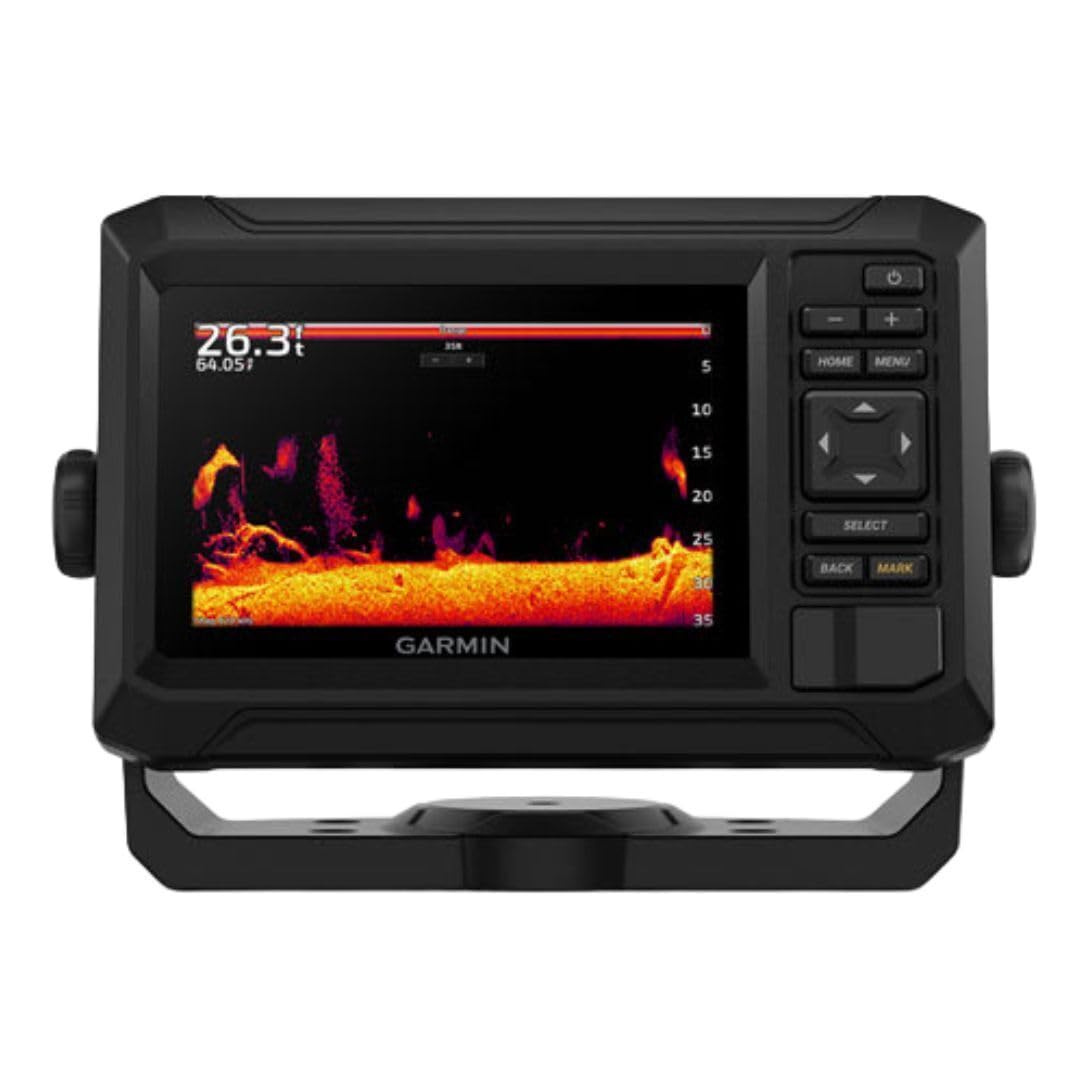
We reach for the ECHOMAP 53cv for one reason above the rest: it arrives with the lake already on it. Garmin Navionics+ U.S. Inland Mapping comes preloaded, so the unit powers up showing contours and shoreline detail instead of a blank grid you have to fill in yourself. If you trailer to unfamiliar water, that first hour on a new lake is worth more than any sonar mode.

The rest of the package holds up. A 5-inch IPS display, CHIRP traditional plus ClearVü scanning through the included GT20-TM transducer, and Wi-Fi that shares waypoints and sonar between compatible ECHOMAP units on the same boat. At 16 ounces it tilts on a bracket or sits flush in a dash, and the split screen, chart on one side and sonar on the other, is how we end up running it most of the time.

One practical note before you commit: give it clean power. A compact chartplotter sharing a circuit that dips when the outboard cranks can drop out and restart, which reads like a fault and is not one. Its own battery or a dedicated circuit settles it for good, and the installation itself is straightforward once that is sorted.

Pros

  • Preloaded Navionics+ U.S. inland charts
  • CHIRP plus ClearVü with the transducer included
  • Wi-Fi sharing between compatible units

Cons

  • Button control instead of a touchscreen
  • Charts cover U.S. inland water only
Our verdict

Buy this one when the chart matters more than the panel: preloaded Navionics+ inland mapping and ClearVü sonar in a compact, network-friendly unit.

Check Latest Price
3

Best for Structure Fishing

Humminbird Helix 7 G4 MEGA SI

84 /100
LBD Score Excellent

Key details

Sonar
Dual Spectrum CHIRP
Imaging
MEGA Side Imaging, 125 ft per side
Mapping
Humminbird Basemap and AutoChart Live
Display Size
7 inches
View on Amazon

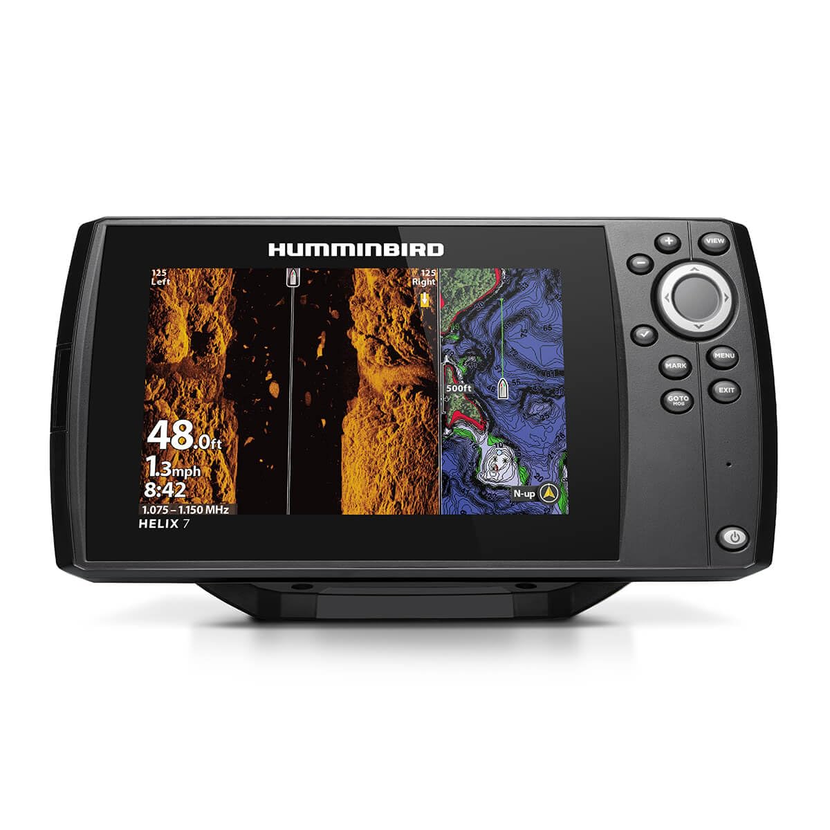
MEGA Side Imaging reaches 125 feet to each side of the boat, which turns a featureless flat into something you can read. You pass a brush pile, catch it on the outer edge of the swath, drop a waypoint and come back to it, instead of idling in circles waiting for something to appear under the transducer. On a 7-inch panel that swath has room to be legible. On a 5-inch screen it is a stripe.

That makes this the pick for structure hunters, and only for them. If your fishing is vertical jigging over a brush pile you already know, or a small lake you have fished for twenty years, the side swath is money you do not get back. If you are learning a reservoir with ledges, channel bends and stump fields, it is the most useful thing in this group after the map itself.

The rest is Humminbird done properly: Dual Spectrum CHIRP in wide and narrow, the 10,000-plus-lake basemap, AutoChart Live contour recording, and the XNT 9 HW MSI 150 T transducer, gimbal bracket and power cable in the box. At 2.1 pounds it is light enough for a quick-release bracket and a swap between boats, and the color TFT holds contrast well enough to read imaging detail rather than just numbers.

The technique is worth knowing before you buy. Side imaging lives or dies on a slow, straight pass, so it rewards a trolling motor you can hold on a heading and punishes a drifting boat. That is what the mode requires rather than a flaw in the unit, and it is the reason we would not hand this to a casual angler.

Pros

  • Side imaging covers 125 feet per side
  • 7-inch panel makes the swath readable
  • Basemap and AutoChart Live included

Cons

  • Body is 10.5 inches wide on a console
Our verdict

For structure hunters this is the pick: MEGA Side Imaging reads 125 feet to each side of the boat on a 7-inch panel with room to show it.

Check Latest Price
4

Best Budget

Garmin Striker 4

93 /100
LBD Score Outstanding

Key details

Sonar
CHIRP and ClearVü
Weight
8 oz
Max Depth
1,600 ft freshwater
Display Size
3.5 inches
View on Amazon

The Striker 4 is the least expensive sensible way onto the water with GPS, and that is the whole case for it. Eight ounces, a 3.5-inch screen and a keyed button pad that works with wet hands, so it goes on kayaks, jon boats and ice buckets because nothing about it needs a console or a wiring project. We keep coming back to it for exactly that reason.

The sonar is genuinely good for the size: Garmin CHIRP traditional plus ClearVü scanning, a flasher view for vertical jigging, an IPX7 water rating, and a maximum depth of 1,600 feet in freshwater and 750 in salt. What it does not have is a basemap. The GPS drops waypoints on a plain plotter, which is all you need to return to a stump bed and not nearly enough to read a lake you have never seen, so keep a paper or phone chart aboard on new water. Mounting is the other thing to plan: the tilt and swivel bracket, transducer and motor mounts come in the box, but the hardware is small, so pick your spot deliberately rather than drilling in a hurry.

Pros

  • GPS waypoints for marking and returning
  • CHIRP and ClearVü sonar at a budget price
  • Flasher view for ice fishing and jigging
  • 1,600-foot freshwater depth rating

Cons

  • 3.5-inch screen only reads well up close
Our verdict

The best budget buy here: Garmin CHIRP, ClearVü and GPS waypoints in an 8-ounce package that suits kayaks, jon boats and ice huts.

Check Latest Price
5

Shore and Ice

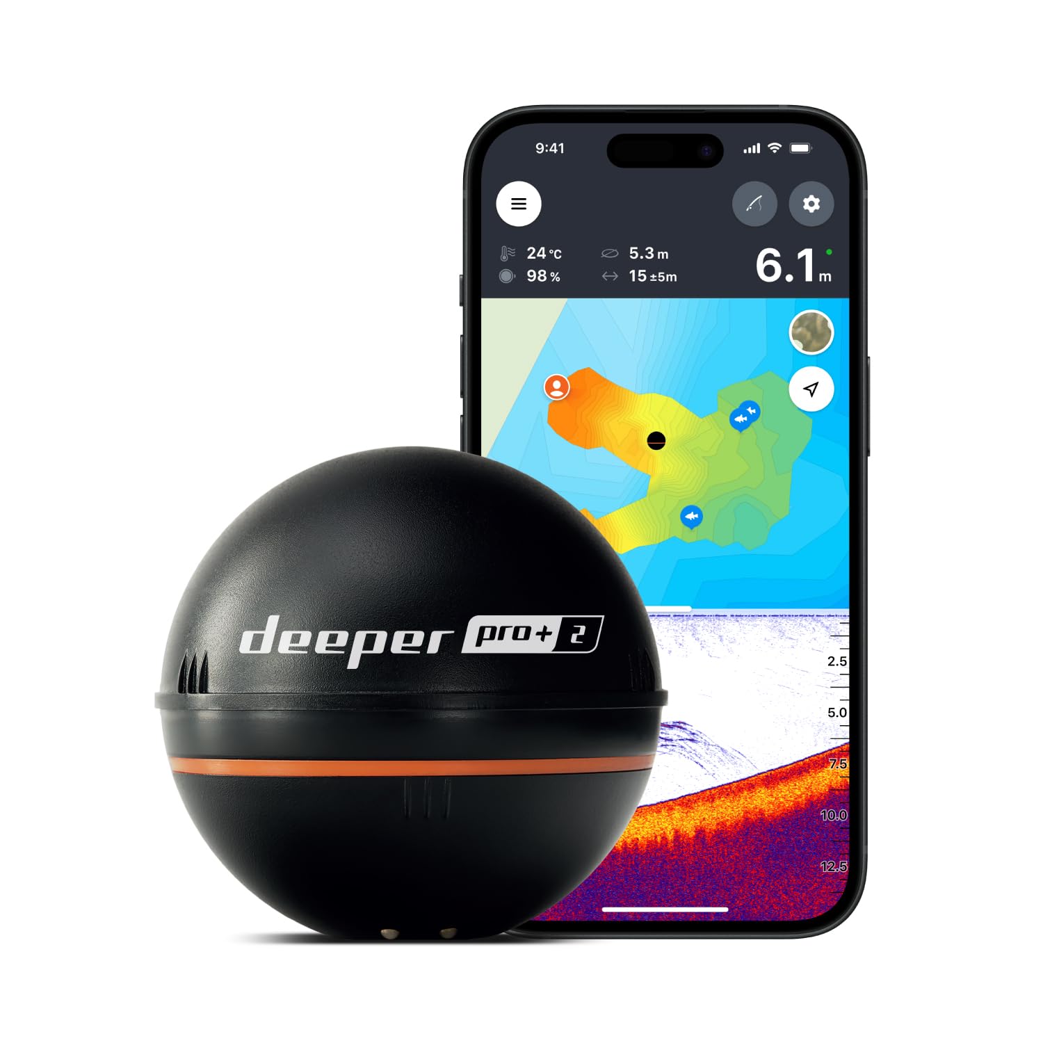
Deeper PRO+ 2

83 /100
LBD Score Excellent

Key details

Beams
Wide, mid and narrow
Weight
3.2 oz
Max Depth
330 feet
Target Separation
0.4 in on narrow beam
View on Amazon

Cast it out, reel it back, and your phone shows you the bottom the whole way. That is the entire proposition of the PRO+ 2, and for an angler on a bank or in a kayak with nowhere to mount a console, it changes more than any screen upgrade. The body weighs 3.2 ounces, so it fishes on ordinary tackle, and the wide, mid and narrow beams let you cover water or pick apart a single drop-off.

GPS is built in, and the Fish Deeper app turns those passes into bathymetric maps you keep, so a pond you have been guessing at for years becomes a contour map after a couple of outings. It charges over USB-C, ships with a neoprene pouch and attachment bolts, and carries a two-year limited warranty. Target separation is 0.4 inch on the narrow beam against 1 inch on wide and mid, so reach for narrow when you want detail on one piece of structure rather than coverage.

What it asks in return is patience with the link. A wireless sonar on the end of your line depends on staying connected, and the display is your phone, so a flat battery or a lost signal ends the session. Judge the accuracy against water you know on the first few trips. Do that and it is the most useful tool here for anyone without a boat to bolt something to.

Pros

  • Maps water from shore, kayak or ice
  • Three beam widths for coverage or detail
  • Fits in a tackle box at 3.2 ounces

Cons

  • No standalone display; the app is the screen
  • Wireless link limits how far out you can read
Our verdict

A castable sonar that maps as it goes: worth it if you fish from shore, a kayak or the ice, and unnecessary if you already have a console unit.

Check Latest Price

How We Chose and Tested These Fish Finders

We started by gathering fish finders on a sensible budget with built-in GPS, then filtered out units that lacked a usable transducer, a screen we could read in daylight, or a plausible way to map the water we fish. That left nine units. Over seven months, we ran them from a kayak, a borrowed bass boat, and a local reservoir, swapping mounts and transducers so each got real water time rather than a bench demo.

Installation was part of the test: we mounted transducers on transoms and kayak mounts, routed cables, and noted which brackets needed a second set of hands or a trip to the hardware store. On the water, we marked brush piles, dock pilings, and drop-offs with waypoints, then returned later to see how close the GPS put us and whether the sonar showed the same structure. We compared depth readings against a hand line and chart data, watched whether bottom held at trolling speed and in chop, and judged image quality by whether CHIRP returns let us tell a school of bait from a sunken limb.

Ease of use got tested with cold, wet hands and gloves: how many taps to change range, how legible the screen was in direct sun, and whether menus made sense without the manual. We also paired each unit to a phone where available, checked connectivity after losing signal, and noted dropouts.

Fish tracking came down to repeatability—could we find the same mark twice, and did the return make sense? Reliability meant running consecutive trips without freezing, rebooting, or needing a mid-day reset. Value was the final filter: what came in the box, what needed an extra purchase, and whether the unit earned its place after the novelty wore off.

How to Choose a Fish Finder with Gps

Waypoints, Basemaps and Live Contours

GPS here runs from a pin you can steer back to all the way to a lake drawn on the screen. The Garmin Striker 4 sits at the simple end: it marks a spot and returns you to it, but the plotter itself is blank. The Humminbird Helix 5 G3 adds a basemap of more than 10,000 lakes plus AutoChart Live, which records your own contours as you drive. The Garmin ECHOMAP 53cv arrives with Navionics+ inland charts already loaded.

Fish one home lake and a basemap plus your own recorded contours beats paying for a premium chart card. Trailer somewhere new every month and the preloaded charts earn their keep on the first trip.

Screen Size and Where You Sit

Three and a half inches is fine at arm's length on a kayak and cramped on a console you read from six feet away. Five inches is the practical middle for a boat, and seven is the size where side imaging and split screens stop feeling squeezed.

Read the display for sunlight readability before you read it for inches, because a bright 5-inch beats a dim 7-inch every afternoon. Remember what the bigger panel costs: console space and a little more draw on the battery.

CHIRP, Down Imaging and Side Imaging

CHIRP traditional sonar is the baseline, and it is what draws fish arches in the water column. Down imaging sharpens the structure directly beneath the hull. Side imaging throws a swath out to each side, which is how you find a brush pile before you are sitting on top of it.

Side imaging is worth the money only if you hunt structure on open flats and can hold a slow, straight course. Vertical jiggers and ice anglers get more from a clean CHIRP picture and a flasher view than from width.

What Comes in the Box

Read the included-components line before you compare anything else. Most units in this group ship with a transom transducer, gimbal bracket and power cable; a control-head-only listing does not, and you buy a compatible transducer separately.

Power is the other half of the install. Give a compact chartplotter a clean circuit, because sharing a run with the engine's starting battery can brown the unit out at crank, which reads like a fault and is not one.

When a Castable Makes More Sense

Neither transducer brackets nor wiring makes sense on a bank or a borrowed kayak, and that is the case for castable sonar. The Deeper PRO+ 2 goes out on your line and streams to the Fish Deeper app over its own Wi-Fi, building bathymetric maps as you reel it back.

You give up a standalone display and a chartplotter, and you depend on a wireless link holding. You gain a unit that fits in a tackle box and works from water you cannot mount anything to.

Frequently Asked Questions

Final Verdict

The Humminbird Helix 5 CHIRP GPS G3 is the one we point most people to. It sits in the middle of this group on price and on screen size, and it is the point where a fish finder starts behaving like a chartplotter without jumping to a premium tier: a drawn lake, contours you record yourself, and CHIRP sonar behind them.

If your water changes every trip, the Garmin ECHOMAP UHD2 53cv and its preloaded Navionics+ charts are the better buy. And if you fish from a bank or a kayak with nowhere to mount a transducer, none of that applies, so cast the Deeper PRO+ 2 instead.